Storm Damage Assessment AI

Find downed lines, broken poles, and trees on wires in drone and patrol imagery, and map every hit before crews roll.
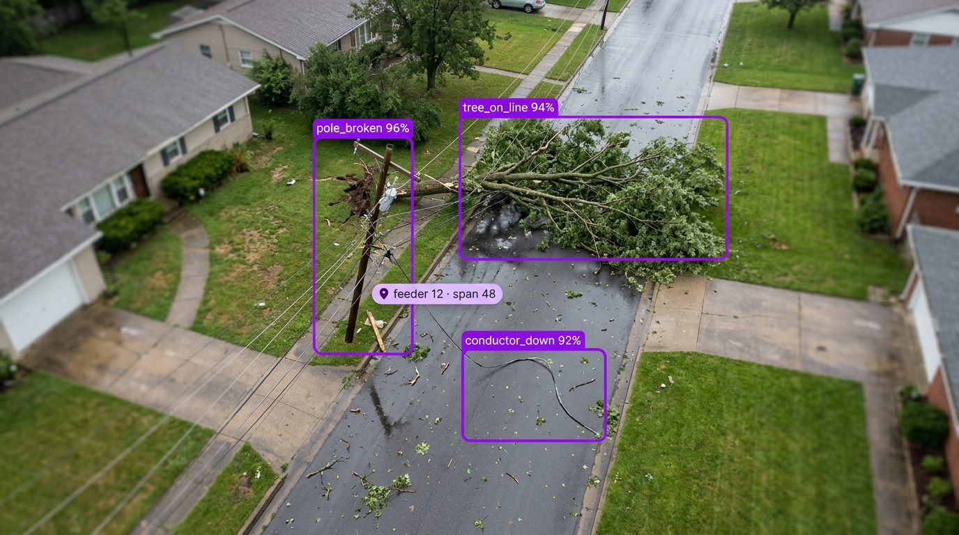
Aerial view of a residential street with storm damage: a broken utility pole, a large tree fallen across the road, and a downed power line, all marked by AI object detection boxes.

Storm Damage Assessment AI for the Toughest Storms, Feeders, and Service Territories

  • Deploy Anywhere, Run Everywhere

    Run storm damage assessment on drone, helicopter, vehicle, and phone imagery, on the edge, on-prem, in your VPC, or via API, with Batch Processing for every flight.

  • One Platform, Full Adoption

    Tools every storm team can adopt, from damage assessors and drone pilots to emergency operations, GIS, and restoration planners, no separate ML team required.

  • Secure, Compliant, and Audit-Ready

    Data stays safe with SOC 2 Type II compliance, encrypted data, and an uptime SLA, with a GPS-tagged image behind every damage record.

  • Downed & Sagging Conductor
  • Broken & Leaning Poles
  • Trees & Limbs on Lines
  • Damaged Crossarms & Insulators
  • Open Cutouts & Damaged Transformers
  • GPS-Tagged Damage Maps

Talk to a Vision AI engineer who's shipped in energy and utilities.

Bring us your toughest storm damage assessment problem and we'll map a working solution.

Ask us about:

  • Solution architecture that fits your storm plan, drone program, and restoration process
  • A live demo on your own imagery from a past storm
  • Deployment options: edge in the field, on-prem, air-gapped, VPC, or Batch Processing in the cloud
  • ROI modeling against assessment hours, outage minutes, crew dispatch, and restoration cost

Over 16,000 organizations build with Roboflow.

  • Rivian
  • Pella
  • Chobani
  • USG Corporation
  • BNSF Railway
  • American Woodmark
Start where you are

Vision AI is transforming businesses

Customers across the board are solving complex challenges and driving meaningful impact.

  • Automotive customer

    $10 million

    Saved by automatically detecting defects on the production line

  • Logistics & freight company

    90%

    Less time spent manually tracking shipping inventory

  • Building materials supplier

    60%

    Lower customer return rate with improved product quality

Scope Every Feeder, from the First Patrol to Final Restoration

Bring real-time intelligence to every storm response with Roboflow vision AI for storm damage assessment. Built for utilities where the first hours after a storm go to finding damage before anyone can fix it, assessors walk and drive circuits one span at a time, and restoration estimates wait on the last patrol report.

Find the damage:

  • Detect downed and sagging conductors, broken and leaning poles, and damaged crossarms in drone, helicopter, and vehicle imagery.
  • Flag trees and limbs on lines, with the same approach used for vegetation management.
  • Spot open cutouts, damaged transformers, and broken insulators, the component checks used in utility asset inspection.

Scope it fast:

  • Run every image and video from a storm flight through your model with Batch Processing, with capacity that scales to the size of the event.
  • Find small damage like a broken insulator in high-resolution aerial images with tiling.
  • Count damage by type and feeder, so planners see how many poles, spans, and transformers each circuit needs.

Map and dispatch:

  • Pin every finding to a map by combining detections with drone GPS and flight logs.
  • Send damage records with images to GIS, outage management, and work order systems.
  • Keep an image record of every finding for after-action reviews and storm cost reports.

Bring intelligence to every storm today. Stop slow damage patrols from becoming longer outages, rough restoration estimates, and crews sent to the wrong place.

‍

Frequently asked questions

What is storm damage assessment AI?

Storm damage assessment AI runs a trained computer vision model (opens in a new tab) on drone, helicopter, vehicle, and phone imagery captured after a storm to find and classify damage to poles, conductors, crossarms, transformers, and vegetation, then maps each finding by GPS for restoration planning. It pairs with transformer and switchgear inspection and Vision AI for drones.

How fast can storm imagery be processed?

Batch Processing runs your Workflow on every image and video from a flight, with infrastructure provisioned and scaled automatically however much imagery comes in, so damage counts are ready as flights land instead of after every image is reviewed by hand. Models can also run on an edge device in the field when the network is down.

Does it work with the drones and imagery we already have?

Yes. Roboflow works with images and video from any drone, helicopter, vehicle camera, or phone. Train on imagery from your own past storms and routine patrols, so the model learns your poles, hardware, and terrain, and the same model keeps working on routine inspection flights between storms.

Can it integrate with our GIS, outage management, and work order systems?

Yes. Roboflow sends damage records, images, and locations over REST (opens in a new tab) or MQTT, or writes them to a database, so they land in GIS, outage management, and work order systems. Roboflow serves as the detection engine, and your storm and restoration teams own the damage categories, priorities, and dispatch.

‍

Stay connected

Get the Latest in Computer Vision First

Unsubscribe at any time. Review our Privacy Policy.