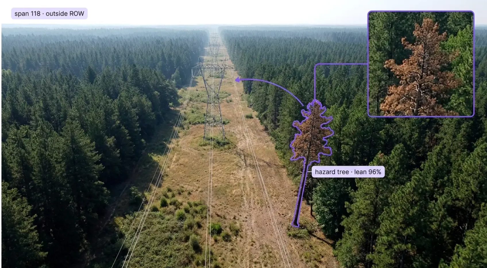
Add a detection layer to every span with vision AI for powerline vegetation management. Built for the operations where a system has tens of thousands of line miles, the LiDAR survey is a snapshot from last year, the fastest-growing spans move most between cycles, and the tree that takes down the line is often outside the right-of-way and dead. Whether you're patrolling transmission by helicopter, flying distribution by drone, buying satellite change detection, or mounting cameras in high fire-threat districts, Roboflow finds the encroachment and the hazard tree and hands the forester a georeferenced span with the frame attached.
Encroachment and Clearance:
- Detect vegetation entering clearance zones under and beside conductors from patrol, drone, and satellite imagery, so grow-in shows up between surveys instead of at the survey
- Flag spans where canopy is closing on the line, and rank them by clearance risk and growth rate, so the trim schedule follows the corridor instead of the calendar
- Detect vines, brush, and regrowth at pole bases and structures, so the ground-level fuel and climbing risk are in the record too
Hazard Trees:
- Detect dead, dying, diseased, and leaning trees inside and outside the right-of-way that could reach the line, so the fall-in risk is a work order instead of an outage
- Classify by health indicators such as crown dieback, discoloration, defoliation, and lean, so the danger tree stands out from the healthy edge of the corridor
- Track hazard trees across passes, so decline and lean that progress get escalated before storm season
Verification, Wildfire, and Systems Integration:
- Verify contractor trim work span by span from post-work imagery, so completion is confirmed by what changed rather than by a signature
- Prioritize high fire-threat districts and PSPS-prone circuits, so wildfire mitigation dollars go to the spans with the highest ignition risk
- Push detections with span, structure, coordinates, and imagery into GIS, vegetation work management, and asset systems, with per-span records that document the program
Bring intelligence to every span today. Stop encroachment, hazard trees, and missed spans from becoming outages, ignitions, or the finding with the span number on it.
More About Powerline Vegetation Management
What is powerline vegetation management with Vision AI?
Powerline vegetation management with vision AI uses computer vision models to find vegetation risk along transmission and distribution lines in patrol video, drone imagery, satellite scenes, and pole-camera feeds: encroachment into clearance zones, canopy closing on conductors, dead, dying, and leaning hazard trees inside and outside the right-of-way, brush and regrowth at structures, and the spans where trim work was or was not completed. Detections come back with the span, structure, coordinates, and frame, ranked by clearance risk, growth, and fire threat, and land in GIS and vegetation work management systems with per-span records that support NERC FAC-003, CPUC General Order 95, and wildfire mitigation plan reporting.
Can Vision AI find a hazard tree outside the right-of-way?
The tree that takes down the line is one of the highest-stakes calls in utility vegetation management: it is often outside the maintained right-of-way, dead or dying, leaning toward the conductor, and standing among thousands of healthy trees that look nearly the same from the air. Deep-learning models trained on your actual corridor imagery, species mix, and seasons learn what crown dieback, discoloration, defoliation, and lean look like on your system, and they run on every span instead of the spans a survey happened to fly. Height and reach come from LiDAR where you have it and from imagery-based estimates where you do not, and tracking across passes turns a single observation into a trend, so the tree that declines over two seasons gets escalated before the storm. Every flagged tree comes back georeferenced with the frame, so the forester is looking at a span and a picture.
Does this replace our LiDAR surveys and trim cycles?
No. LiDAR keeps its role as the clearance measurement of record, and the trim cycle, the NERC FAC-003 transmission program, and the CPUC General Order 95 clearances keep their schedules and their standards. Vision AI adds what a survey and a cycle alone do not produce: coverage from patrol, drone, and satellite imagery between LiDAR flights, hazard tree health that a point cloud does not carry, span-by-span verification that trim work was done, and a ranked list that tells the cycle where to go first. LiDAR clearances, vision detections, and completed work land in the same GIS and program record, and the span that would have grown into the line before the next survey gets trimmed this season.
Can it integrate with our GIS, vegetation work management, and asset systems?
Yes. Roboflow Inference exposes a standard API and supports common industrial protocols, so detections flow into your existing systems: Esri ArcGIS and utility network models, vegetation work management platforms such as Clearion and contractor systems, asset and work order systems like IBM Maximo and SAP PM, and outage and wildfire mitigation reporting, through REST, MQTT, and direct database writes. Each detection carries the class, confidence, span, structure, coordinates, frame, and pass, so a forester can issue a trim or removal order with the evidence attached, contractors can be verified against post-work imagery, and the program can report by circuit, district, and season, with a full record behind every span.