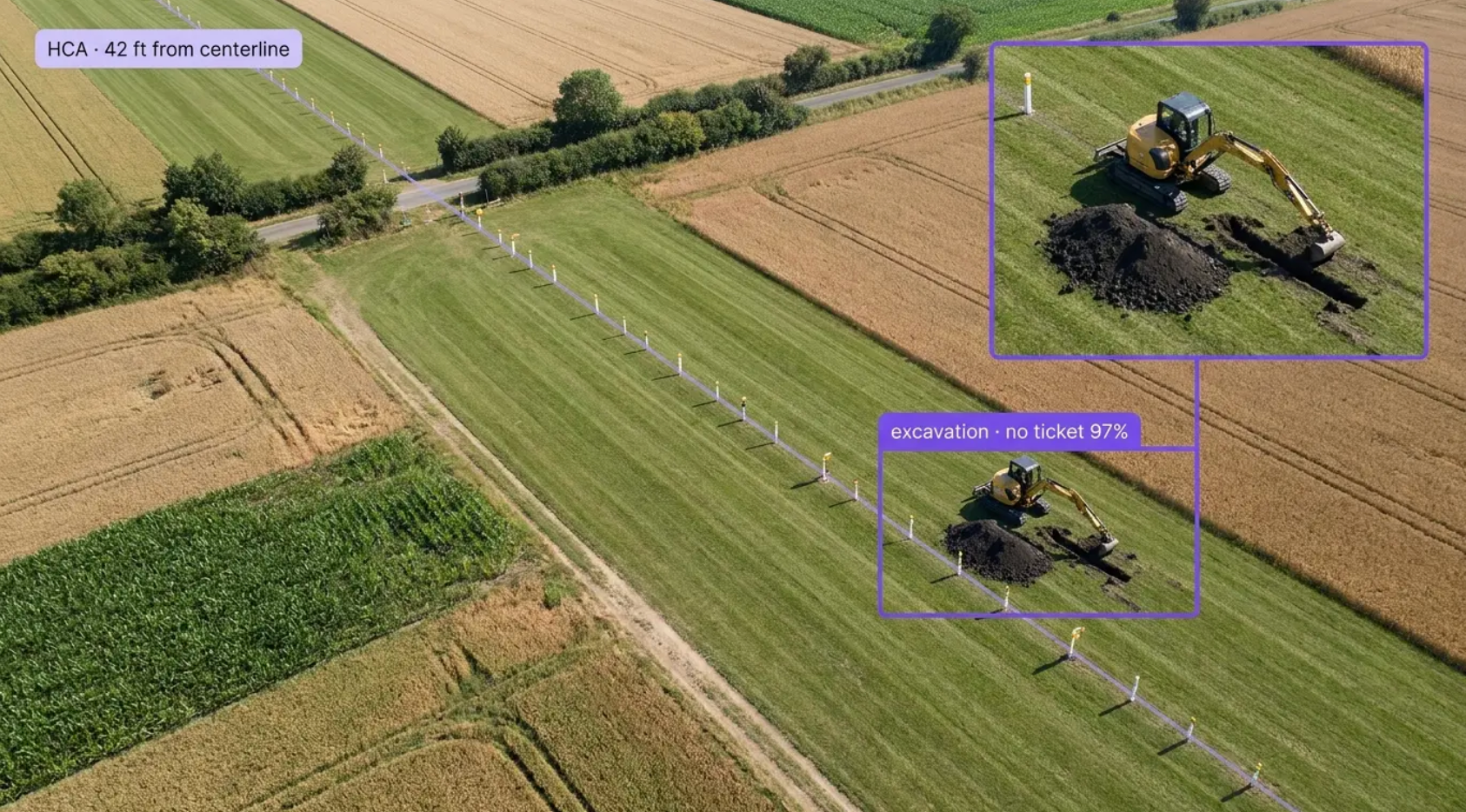
Add a detection layer to every mile of right-of-way with vision AI for pipeline right-of-way inspection. Built for the operations where a patrol flies hundreds of miles in a morning, an observer has seconds per frame, and the thing that matters is a small yellow machine on a brown field, a wet patch in the grass, or a fence line that moved since the last pass. Whether you're flying fixed-wing patrols, running drone corridors, buying satellite change detection, or mounting cameras at crossings and high-consequence areas, Roboflow finds what's on the easement and hands the crew a georeferenced frame, with a record behind every mile.
Third-Party Activity and Encroachment:
- Detect excavators, backhoes, trenchers, drilling rigs, and stockpiles inside and adjacent to the easement, and flag activity with no matching one-call ticket
- Detect new structures, fences, roads, and land-use change on the right-of-way between passes, so an encroachment is a work order instead of a discovery years later
- Track activity across passes, so equipment that stays or work that spreads toward the centerline gets escalated
Ground and Pipe Condition:
- Detect erosion, washouts, slope movement, and exposed or spanning pipe after storms and floods, with the frame and the coordinates
- Detect vegetation encroachment, woody growth, and canopy closing over the corridor, so mowing and clearing crews go where the corridor needs them
- Detect leak indicators including sheen, pooling, discolored soil, and stressed or dead vegetation along a line, so a survey can be dispatched to a spot instead of a segment
Patrol Operations and Systems Integration:
- Run detection live in the aircraft or on the drone, and on archived footage, so a fifty-mile patrol comes back as a ranked list of frames instead of hours of video
- Prioritize by high-consequence area, class location, and proximity to the centerline, so the review queue starts where the risk is
- Push detections with coordinates and imagery into GIS, integrity management, and work order systems, with per-flight records that document the patrol
Bring intelligence to every mile today. Stop encroachments, washouts, and exposed pipe from becoming strikes, reportable incidents, or the finding that surfaces after the fact.
More About Pipeline Right-of-Way Inspection
What is pipeline right-of-way inspection with Vision AI?
Pipeline right-of-way inspection with vision AI uses computer vision models to find what a patrol is looking for on the easement, in patrol video, drone imagery, satellite scenes, and fixed-camera feeds: third-party excavation and heavy equipment, new structures and encroachment, erosion, washouts, and exposed pipe, vegetation encroachment, and leak indicators like sheen and stressed vegetation. Detections come back with the frame and coordinates, ranked by proximity to the centerline and high-consequence areas, and land in GIS and work order systems with per-flight records that support PHMSA 49 CFR Parts 192 and 195 patrol requirements and integrity management program audits.
Can Vision AI find an excavator in aerial patrol footage?
Finding third-party equipment from the air is exactly where right-of-way programs feel the most pressure: a patrol covers hundreds of miles in a morning, the target is a machine a few pixels wide on a field that changes color with the season, and the observer gets one look. Deep-learning models trained on your actual patrol imagery, altitudes, and terrain learn what excavators, backhoes, trenchers, rigs, and stockpiles look like from your platforms, and they run on every frame instead of the frames a person happens to be watching. Small-object detection at altitude is the hard part, and it is the part the models are built for: tiling and high-resolution inference find the small yellow machine on the brown field, and cross-referencing with one-call tickets turns a detection into a call. Every flagged frame comes back georeferenced, so the crew is looking at a spot on a map, not scrubbing video.
Does this replace our aerial patrols under 49 CFR 192.705 and 195.412?
No. The patrol keeps flying at the intervals the regulations require, 49 CFR 192.705 (patrolling of gas transmission lines) and 49 CFR 195.412 (inspection of rights-of-way and crossings under navigable waters for hazardous liquid lines), and the pilot and observer keep their eyes on the corridor. Vision AI adds what a patrol alone does not produce: a detection on every frame instead of the ones in view, a ranked review queue by high-consequence area and class location, change detection between passes, and a per-flight record that documents what was covered and what was found. Patrol observations and model detections land in the same GIS and integrity record, and the encroachment that would have surfaced next season surfaces this week.
Can it integrate with our GIS, integrity management, and work order systems?
Yes. Roboflow Inference exposes a standard API and supports common industrial protocols, so detections flow into your existing systems: Esri ArcGIS and PODS or UPDM data models, integrity management platforms, work order and asset systems like IBM Maximo and SAP PM, and one-call and ticket management systems, through REST, MQTT, and direct database writes. Each detection carries the class, confidence, coordinates, frame, flight, and platform, so a right-of-way agent can open a ticket with the evidence attached, and integrity engineers can trend encroachment and ground condition by segment across patrols, with a full record behind every mile.